

Just Like Nothing (else) on Earth: Blue Ridge Mountain Road (Revisited)
By Tim Jon
I had made the decision in all innocence: “It’ll be kinda fun to drive this stretch on a misty, foggy morning.” Right.
In the 10 years or more that had passed since I’d been on top of ‘the Mountain’ under these conditions, I had blissfully forgotten just how limited the visibility could be. Limited?! After I’d left Route 50—John Mosby Highway—and started the real climb on Route 601—Blue Ridge Mountain Road—with hairpin turns that call for crawling speeds anyway—I started wishing I’d just headed back to Leesburg along more ‘pedestrian’ paths, and it was right about then I discovered I couldn’t see whatever driveways I was passing, in which I may have been able to reverse course.
At 15 to 20 miles an hour, I didn’t trust myself to select a turn-around spot. This was unheard-of, at least to my ears. So I continued, knowing I had something like a dozen miles (like this) to go, until I’d reach the relative security of Route Seven – Harry Byrd Highway.
This all started with a simple photo session in the nearby village of Paris (Virginia, not France or Texas); this little hamlet lies nestled on the shoulder of the Blue Ridge, much like Bluemont just to the northwest. I knew the drive home would be about equidistant if I skirted the top of the Mountain, and I hadn’t been up there for a while, and, yeah, sentimentality and romance got the better of me. Not for the first time, either.
Now, I’m climbing the Appalachians, at around 6:30 in the morning (fortunately it was a weekend, with no business traffic), with basically no visuals. Images flitted past my windshield that seemed to emanate from my memories of “The Wizard of Oz:” I kept watching for Dorothy and Toto (wouldn’t want to hit them), but instead of seeing any of those familiar characters, I began driving through a veritable ‘deer barnyard.’
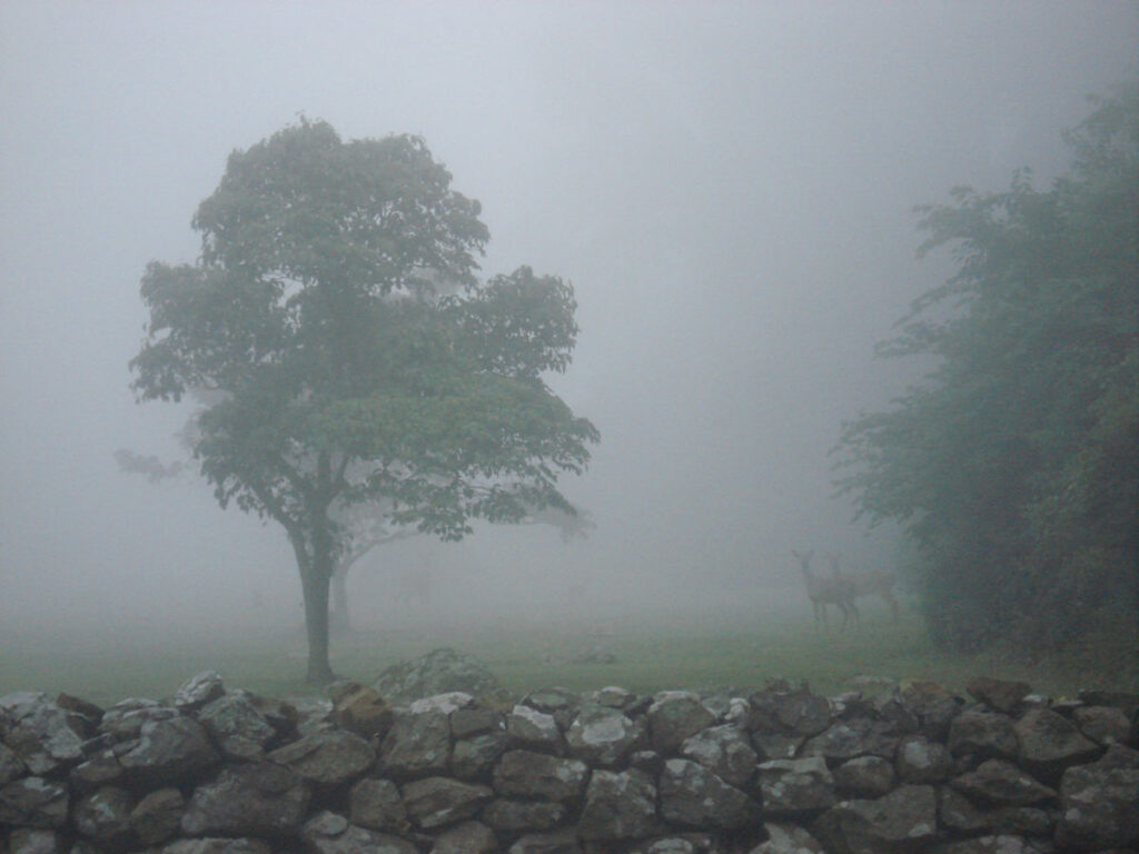
These animals seemed not the least concerned about a storytelling wayfarer driving something that looks a bit like one of the Blue Angels on wheels. Well, I was IN the clouds.
I hadn’t come up here for ‘an experience.’ I hadn’t come up here for pictures. I knew I should get some ‘shots’ of these atmospheric conditions, but I couldn’t just stop in the middle of the road. I mean, I think I was still on the road. Who’s to say? I kept driving. I probably still have the etched pattern of the steering wheel on my hands. Yup.
And you? In all innocence, you truly believe, “Well, he’s over the worst, this nut will soon reach the summit and start descending, and the fog will thin out.” Keep thinking that.
Meanwhile, our intrepid traveler reaches the vicinity of the Mount Weather Emergency Operations Center. Yeah, that place. Like, if you find out their secrets … Well, let’s just assure them we don’t know about any of their doings.
Now, in the thickness of the fog, or the thinness of my sensory perception, I could barely make out the security fencing on my left and right (“Don’t go that way!”); I continued under an overpass of some sort and through at least one intersection, hoping I was staying in the Public Right of Way.
I’d been to the turnaround area on Old Blueridge Road, delivering mail—probably hundreds of times—but that was at least 10 years ago, and my memories don’t always match up with current conditions. But I kept driving, and I evidently made it past this top secret facility with no bullet holes or brain implants (that I’m aware of).
I was now at least in somewhat familiar territory, having previously served the remaining section of my drive for the US Postal Service. Of which I was very grateful. I found some very limited areas in which to pull over and capture some of the remaining fog, and clouds, and palpable moisture in the air.
Now, the photos I took up there are by no means the thickest patches of obscurity; I simply could not just stop in the worst sections. But I came home with some pretty good images of what it’s like to be almost lost in the fog on top of Mount Weather.
And if you need any more chills from that day, I can say I didn’t even see the memorial marker for the tragic crash of Flight 514 from 1974. All on board lost their lives when their Boeing 727 was flown into the Mountain.
I’ve written of this elsewhere, and I’ll always remember taking phone calls at the radio station– every year on the First of December—from local rescuers who still felt immersed in the aftermath of the tragedy. The Mountain commands cautious behavior from its visitors.

Comments
Any name-calling and profanity will be taken off. The webmaster reserves the right to remove any offensive posts.
