
")
Western Loudoun to lose one of its two districts
Supervisors advance Letourneau-Turner redistricting plan
By Laura Longley
Where do you draw the lines? That is the question Loudoun’s supervisors, mayors, and engaged citizens grapple with every 10 years when, post-U.S. census, the County undertakes the onerous task of local redistricting. Their decision impacts the lives of present and future Loudoun residents for the next decade.
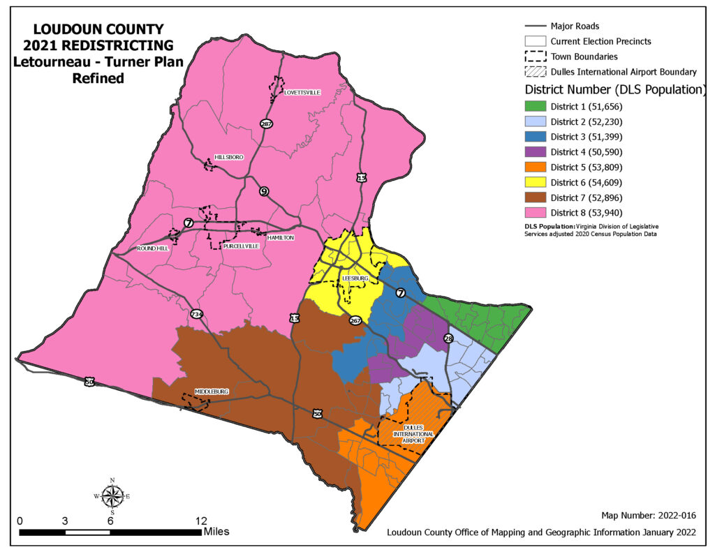
In 2011, when the County last redistricted, the process yielded six districts in eastern Loudoun and two in the west (one of them including the suburban community of Brambleton), plus a supervisor at-large. Last June, Loudoun County took up this exercise again, inviting all interested citizens to submit maps that would be measured by County staff against nine benchmarks, including equal representation and preservation of communities of interest.
Two maps surfaced for presentation to the Board on Feb. 15. One was proposed by the Coalition of Loudoun Towns (COLT), a second was developed by Supervisor Matt Letourneau (R-Dulles) in collaboration with Supervisor Mike Turner (D-Ashburn). Named for them, the Letourneau-Turner map received the majority of supervisors’ votes to move forward for staff tweaking and a public hearing on March 15. But the Board did not arrive at the decision without a struggle.
While Loudoun citizens have become accustomed to contentious School Board meetings, seldom do they hear supervisors begin so many statements with the phrase “with all due respect” before calling out actions and positions of the towns’ mayors and colleagues on the dais. Battle lines formed around population distribution vs. communities of interest as the basis for district boundaries.
“By making sure districts have approximately the same number of people, redistricting can help to ensure residents have equal representation on the Board of Supervisors and School Board,” the County’s website explains. “It also affects for whom residents vote and where they vote, based on how the local electoral boundaries are drawn …
“At its June 21, 2021, meeting,” the site made clear, “the Board of Supervisors voted to retain eight local election districts. Given the county’s 2020 population of 421,129, the ideal district size would be 52,641; since each district can be over or under the ideal size by five percent, the minimum district size will be 50,009 and the maximum number of residents in a district will be 55,273.”
The Letourneau-Turner plan reflects this population distribution, which leaves western Loudoun with one district, not two.
Meanwhile, the seven mayors who make up the Coalition of Loudoun Towns developed a plan around “communities of interest,” focusing on western Loudoun’s landmass—nearly two-thirds of the County—and the unique issues facing current and future residents of the rural policy area. Their aim: to maintain the two western districts, Catoctin and Blue Ridge.
At the Feb. 15 Board meeting, Al Van Hyuck, one of the County’s leading preservationists, made the “communities of interest” case. “I’m here tonight to ask you to send both the COLT revised redistricting plan and the Letourneau-Turner plan together back to staff for the final tweaking so we end up with two majority rural development districts …
“The rural policy area is over 200,000 acres,” Van Hyuck continued. “It represents 30 percent of the economy of Loudoun County. It is the home to our tourist industry with breweries, wineries, and events centers that are so vital to our County. It’s expected to absorb 11,000 new residential units according to the (2019 Comprehensive) plan, which represents 25 percent of all the residential growth that’s going to be coming. It’s the home of all the towns—except Leesburg—and 12 rural villages, all of which right now are trying to get village plans to protect themselves from inappropriate development.”
Bridge Littleton, Mayor of Middleburg, laid out the case for popular support of the COLT plan.
“In all but one of the statistical and measurable categories, which were independently assessed by the staff, COLT’s map either tied or exceeded the other two maps …We broke down the data of the nearly 500 votes that were submitted by Loudoun citizens … and neither of the other maps individually or combined achieved half of the support that the COLT map did. Countywide, the COLT map received 86 percent of the support, with the Letourneau-Turner map receiving 10 percent and the (Avram) Fechter map receiving 4 percent … If we remove the two western districts from the tally, the COLT map still received 75 percent of the County support with the Letourneau-Turner map and Fetcher map receiving 17 and 8 percent respectively.
“Our request is that the Board consider this input from the staff and proceed to your next steps with the COLT map as a baseline. Then, using the best elements of the other maps, [staff could] tweak and make adjustments as needed for the best result.
“As a body,” Littleton concluded, “COLT would fully support and publicly endorse this approach with you here today and … when it eventually goes to the [Virginia] Attorney General for approval.”
“In a word, that is hogwash,” said Supervisor Turner. “Absolute hogwash.” He went on, “[It is a] clear effort to misinform the public, [implying] that in a Countywide poll 86 percent of the people support the COLT plan, and that’s not true …
“I find it very, very disturbing that all of the mayors and the two supervisors from the rural districts would actively promote this deliberate mis- and disinformation … Five hundred people were coached to go into the system and make comments. There are 421,000 people in this County—500 people made comments. That is not the bulk of the County. So, let’s just dispense with that.”
“COLT outperformed all the others,” agreed Letourneau, “because it’s the only one that has had an orchestrated campaign going on for the last several weeks, including email to the Board in favor of it. I can assure all my colleagues that if you would get 500 emails in favor of the Letourneau-Turner plan, I could make that happen by sending out an email to my mailing list asking people to support that plan because it’s the best for my area. I’ve always said we cannot go simply by how many emails we get.”
It’s the numbers that count, Turner emphasized.
“Ten years ago, when I did this process, we had 45,000 as our benchmark, plus or minus 5 percent, and the east was much less populous. The percentage of the population –that is, the one person-one vote theory, the basis of democracy—worked out to about 1.5 – 1.6 supervisors for the west, and we rounded up to get two supervisors, but we had to grab Brambleton to do that.
“The west has been saying for years now, ‘We don’t want more people out west.’ Well, there’s been an explosion in eastern Loudoun County, and now the percentages work out to almost exactly 12 percent of the population west of Rt. 15. Twelve percent of eight supervisors is one supervisor. If we believe in one person-one vote, the west only gets one vote. They only get one supervisor. The math is sacrosanct. In this whole drill, you can’t play with the math.” Turner concluded.
Chair Phyllis J. Randall (D-At Large) pointed out that with the Letourneau-Turner plan the west actually would benefit from the Letourneau plan because “as it stands, you will have three people, three of nine, to cover parts—wholly or part of—western Loudoun County.” She added, “The ironic part of the COLT map is it’s the only map that will not require a supervisor to live in the west. How are you going to fight about the fact that the west is so important, but then you could have all nine supervisors living in the east?”
The Letourneau-Turner map is moving forward to a March 15 public hearing with the support of seven supervisors: Juli Briskman (D-Algonkian), Sylvia Glass (D-Broad Run), Kristen Umstaddt (D-Leesburg), Vice Chair Koran Saines (D-Sterling), and Letourneau, Turner, and Randall.
Two supervisors —Tony Buffington (R-Blue Ridge) and Caleb A. Kershner (R-Catoctin)—voted for the COLT plan.
That plan will now move forward to a Board of Supervisors public hearing on March 15, followed by staff refinement before the final plan is presented to the Board of Supervisors in May then sent on to the Attorney General. Implementation of the new map is expected by August.
Continue reading in this news section
Comments
Any name-calling and profanity will be taken off. The webmaster reserves the right to remove any offensive posts.

Would love to see a side by side comparison of population per district and number of votes cast in the last election. Perhaps there is more causality to this decision than just a balance of resident population?