

Just Like Nothing (else) on Earth: Chestnut Hill Road
By Tim Jon
Maybe it’s a good thing I didn’t get any pictures from that climb up the first hill; I certainly know it’s a good thing that I didn’t try. Going up what seemed like a 30-degree gradient, with no shoulders along the roadway, and a guard rail that I wished were a lot sturdier, I inadvertently caught glimpses of the Potomac River off to the right side—and what seemed like at least a mile below me.
I had noticed Route 32—Chestnut Hill Road—as the possibility of an interesting drive among the Blue Ridge Mountains on my last trip up to Harpers Ferry—in the north-western corner of Loudoun County. I have to admit, it held my interest, all right.
Even though the road was paved, I couldn’t help hoping that the Good Earth would hold up underneath it, as I carefully made my way skyward; the way the soil was eroding away at the roadside made me wish I had a set of wings and a parachute, just in case.
And I haven’t even mentioned the sights on the opposite side of the road: stout cabling was running along a good portion of the sheer rock cliff, which was hewn out of the Appalachian bedrock, so unceremoniously thrust up to create all this topography. So: fear of falling rock on my left, and the dizzying sensation of concerns of a quick tumble into the river on my right; piece of cake, I didn’t say to myself.
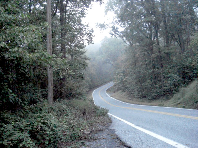
But I kept on climbing and eventually reached a point where the road crested, and then dipped and corkscrewed for what appeared to be the unforeseeable future. I passed hamlets, villages and lone homesteads along the way, but it seemed like a great deal of distance had been covered before I found a partially civilized area to pull off for a quick stretch and a brief camera session.
Everywhere I looked, the world seemed at odds with itself; the terms uphill and downhill had lost all meaning: the terrain was a swirl of cockeyed angles and curving levels.
I fell back into my vehicle (at least that’s where I landed) and proceeded along my chosen path. My next stop came in a spiritual form—Silver Grove United Methodist Church; the historic, wooden structure lay nestled amongst the hills and the clouds, and I experienced the feeling that heaven surely must be just a little bit closer at this elevation. I mean, just in case.
What with all these crazy twists and turns, I felt I could fall upward as easily as any other direction. Just another experience of what I call the Loudoun County vortex—in which things are definitely not always what they seem.
My continued travels next took me to a former place of worship—this time what appeared to be an abandoned church building across the highway from the existing Chestnut Hill United Methodist Church—which is a sturdy-looking brick structure; the older location exhibited a great deal of character, history, and to my finding—some wonderful stories.
Just across the roadway at 90 degrees I took in the sight of a small (story & a half), wooden structure with the sign “Wesley House” just above the front door. Again, I sensed a great deal of history, isolation and perseverance. I’m sure these facilities will pass several more tests of time, as they undoubtedly have in the past.
I was grateful to spend a bit of time at these locations, and ostensibly soak up a bit of their solidity, after the state-fair carnival-ride effects of my recent trip on Chestnut Hill Road.
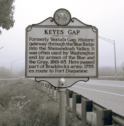
I hadn’t really been monitoring my mapping system, and shortly after re-embarking on my journey of discovery, I could see the obviously major intersection approaching with Route Nine – Charles Town Pike, at Keyes Gap– pretty much at the location of the pass between a couple of peaks of the Blue Ridge.
I stopped long enough to get acquainted with the clouds passing overhead—or rather, at eye level—and attempted to distinguish the line between solid ground of the hills, and the (mostly) gaseous makeup of water vapor and lighter elements composing a very refreshing breath of air.
I was grateful I’d picked a relatively pleasant time of year to pause at this elevation. I shook my head as I recalled making mail deliveries within a quarter-mile of this spot, with a foot of new snow on the ground.
Don’t try that at home. Almost as hair-raising as thinking about photography when making the initial climb up ‘the mountain’ on the other end of Chestnut Hill Road.

Comments
Any name-calling and profanity will be taken off. The webmaster reserves the right to remove any offensive posts.
