
")
County to Purcellville – Approve this new design now or else …

By Valerie Cury
Loudoun County officials are trying to force the Town of Purcellville to accept the County’s altered design for the Rt. 7/690 Interchange. This pressure meanwhile disregards the Town’s due process and the expressed desires of most of the Town’s citizens. Purcellville’s legislative rules and procedures require the Town to make decisions on significant changes to projects, such as the County’s proposed alterations to the Rt. 7/690 Interchange design, through its elected representatives on the town council and based on the advice of the town’s boards, commissions, committees and staff.
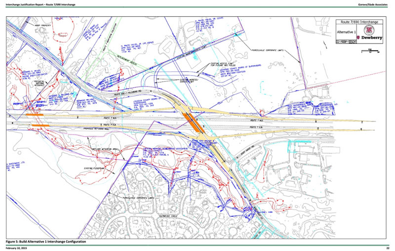
This is the Alternative 1 design which was approved by a previous Town Council in 2013. It has signalized ramps.
Purcellville’s citizens – who are also Loudoun County citizens – express their aspirations for the future of their town, including areas that the future Rt. 7/690 interchange will impact, through elections and through their Commonwealth-mandated comprehensive plan, which, in this case, seeks to preserve wetlands, floodplains, and the Town’s Historic Corridor Overlay District.
In contrast, public statements by County officials advocating for the rapid implementation of the altered Rt. 7/690 Interchange design have focused on the prospect of losing Commonwealth funding if the town does not set aside its rules and procedures and immediately accept the new design.
These County officials have provided scant evidence or explanation to Purcellville citizens on whether and how their proposed departure from the design to which the Town and the County agreed in 2013 will improve the health, safety, and welfare of Purcellville and its neighbors.
The originally agreed on Rt. 7/690 Interchange design included traffic lights in lieu of roundabouts.
County officials, together with senior Town staff and the Virginia Department Of Transportation altered the design significantly on July 10, 2019 by incorporating two traffic circles with pedestrian crosswalks close to the circles that encroach on and alter 14.2-acres of wetlands in Purcellville belonging to the Catoctin Meadows Homeowners Association.
The Town’s senior management failed to notify Purcellville’s elected officials, its Planning Commission, and its citizens of this new design – bypassing the required public processes, public hearings, and votes by the elected body necessary to approve such significant alterations.
One of the biggest issues requiring transparent, public discussion is evaluation of the benefits and costs that the altered design would introduce, if adopted. According to County and VDOT studies, the currently approved 2013 design for the Rt. 7/690 interchange provides roughly the same level of service as the proposed altered 2019 design.
No County or Commonwealth officials have provided citizens data indicating significant benefits from the altered design. By contrast, citizens from the Catoctin Meadows neighborhood have identified negative environmental impacts from the altered design and pinpointed added stresses the design would introduce to other intersections in Purcellville, such as the one at Hirst Road and Rt. 690.
The County would need temporary easements for construction, which would allow County officials to cut trees and disturb land and creek beds – and the County wants the Catoctin Meadows HOA to hold it harmless from any related losses or damages resulting from work on the interchange.
The Catoctin Meadows HOA is asking that the project introduce no changes in the current Federal Emergency Management Agency flood plain map, as it directly impacts Catoctin Meadows residents’ properties.
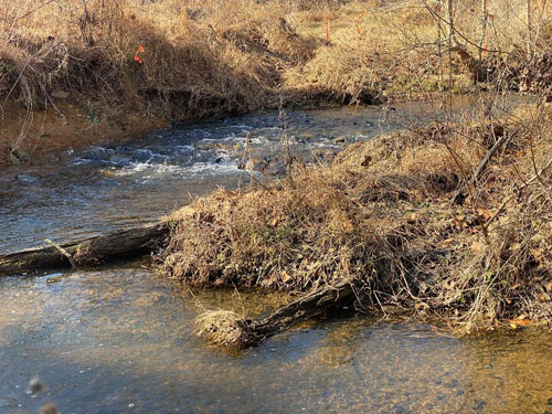
This is the South Fork of the Catoctin Creek which feeds the Town of Purcellville’s parks and trails. This is part of the 14.2 open space wetlands owned by the Catoctin Medows residents.
The HOA is asking for the County to maintain the wetlands and stream beds of the South Fork of the Catoctin Creek, to remain compliant with Purcellville’s ordinances. The HOA is also asking for the County to mitigate road noise, and to reinforce the view shed. The HOA wants the County to put any remaining property in a conservation easement.
All of these requests are in accordance with the aspirations captured in Purcellville’s comprehensive plan. The HOA’s requests are in keeping with the Town’s citizens’ vision for Purcellville.
The Purcellville Town Council at its Dec. 13 public meeting voted unanimously to send the Rt. 7/690 Interchange design alteration issue to the Purcellville Planning Commission for review.
Town Council Member Tip Stinnette, who is also the president of the Catoctin Meadows HOA, said the issue should go to the Planning Commission to “have them reevaluate the applications … then proffer a recommendation to the Town Council.” He stressed, it’s a matter of process.
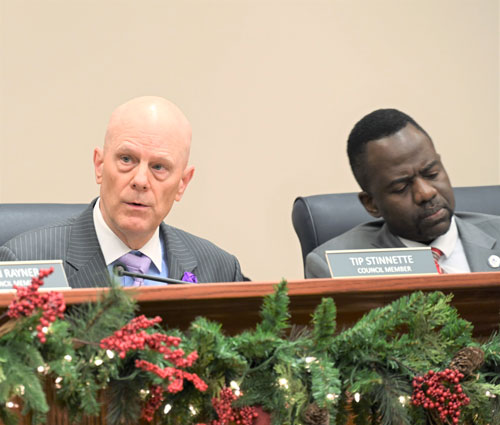
L to R: Council Member Tip Stinnette and Mayor Kwasi Fraser in their final Town Council Meeting of their term in office.
“There is currently an easement between the Town and the HOA to maintain the floodplain … The County needs to amend or change that easement agreement … and the HOA members would have to examine what the changes would be …,” said Stinnette.
The County owns lot 74 of the Catoctin Meadows neighborhood, which is in Purcellville’s HCOD. “If the County wants to demolish that property, they must comply with Historic Corridor Overlay District demolition requirements,” he said.
Stinnette said the County needs to talk to and share documents with the HOA and thus far it has not done either. He said that the County has asked the Town to vacate its rights to their easement with the Catoctin Meadows wetlands. Procedurally, this would have to be accomplished via a public hearing, first through the Town’s Planning Commission. The Catoctin Meadows wetlands are a consistent feature in the Town’s Comprehensive Plan.
Stinnette also called for “a public information session. This is a complex issue with a lot of branches … I think we need to have a public information session that informs Planning Commission deliberation … We need to put sunlight on this, and do it correctly.”
Stinnette stressedthat the Catoctin Meadows HOA is not against the interchange., but that they “want the Town to comply with its existing processes. We want the County to comply with its existing processes, and we want the project to be fully compliant with the Town’s Comprehensive Plan.”
Mayor-elect Stan Milan said, “The important thing is the second and third level effects of this project moving forward.” The floodplain issue of the County’s proposed alternative to the agreed upon design, “is not in concurrence with our Comprehensive Plan,” he said. With the addition of the two roundabouts – “that’s going to encroach on our streams which will affect downstream vegetation and parks … There’s a lot more involved here than approving this project …”
Mayor Kwasi Fraser said, “My concern is that in 2013 the then Town Council approved a design.”
He was then interrupted by Engineering and Planning and Development Director Dale Lehnig who said, “They approved a location and a concept.” Fraser asked, “So the concept. Is the concept a design?” Lehnig responded, “The concept is a concept.” Fraser said, “So they approved a concept which was Alternative 1 [the originally approved design].” Lehnig said, “They approved a concept showing a location of the interchange at that crossover.”
Asked Fraser, “Didn’t they call that concept Alternative 1, and they did a level of service study with multiple tables?” Lehnig replied, “They called it Alternative 1.”
“Yes,” said Fraser, and they did a level of service with tables showing the community the impact of Alternative 1 on several road interchanges … but there was a design attached to that concept which was Alternative 1. I saw several tables outlining Alternative 1 and the impact on different roads or arteries throughout the Town.”
Fraser asked, “Wasn’t that concept then changed into this diamond shape with two roundabouts in 2019?”
“So,” said Lehnig, “the original concept was a diamond interchange, right, but it had signalized lights at the intersections as the ramps came off.” Lehnig said that the original design had “at least as good a level of service with the roundabouts …”
“But,” asked Fraser, “in 2013 there were no roundabouts?” Lehnig said, “In 2013 there was an interchange; they didn’t specify whether or not it was a roundabout or a signal.”
“Dale, I don’t mean to go back and forth, but I read about 200 pages of documents before I ran [for office]. I was supportive of the Rt. 7/690 Interchange based on the decision that was made in 2013. The basis of my support was that in that 200 plus page Interchange Justification Report, it stated that with the 7/690 Interchange as conceptualized, it will improve the level of service on Hirst Road and that’s why I supported it then.”
Lehnig disputed that, “I don’t think it said that it would improve the level of the intersection of Hirst Road.”
Fraser said he could show her the table that confirms the data. “What I am hearing here is a need for transparency,” he said. “That transparency was not provided when the new design in 2019 was created. “I get it that the Town [senior management] and the County wants us to go at this with accelerated speed. But the question is velocity versus speed. Velocity has process, and has direction. Speed is just going mindlessly … We can have everyone have agency in developing what is right for the community.”
The Planning Commission will review the original and altered Rt. 7/690 design proposals and make a recommendation to the Town Council based on which option with which suggested alterations or mitigations provides the greatest benefit and least cost to the health, safety, and welfare of Purcellville’s citizens. Then, the Town Council must decide how Purcellville will respond to the County’s proposed alterations to the originally agreed upon Rt. 7/690 Interchange design.
The new design which has not been publicly vetted
Concerns were raised about the project implementing “uncontrolled” roundabouts also known as traffic circles.
In April 2018, Dewberry Consultants, LLC hired by the County for the roadway and civil design services, noted that the use of traffic circles was considered as part of the requirement for the Interchange Justification Report. In this report a roundabout study was performed and found “unfeasible in the project location.”
The previous design known as Alternate 1 was approved by a prior Town Council in 2013. The design had signalized modest ramp designs. This design was replaced in 2019 with open pass roundabout intersections pursued by the County, with input from VDOT and the Town of Purcellville senior management.
Neither the Purcellville Town Council nor the community knew about this new design and thus were not provided the opportunity, through Planning Commission and Town Council, of public information meetings, public hearings, or detailed review of the revised design.
There has not been any community, land owner engagement, nor Council approval on the new roundabout design, encroaching further into the Catoctin Meadows owned 14.2 acres of green open space wetlands, forests and wildlife area also – home of the South Fork of the Catoctin Creek which feeds most of Purcellville’s nature parks with clear stream bed fed water.
This new roundabout design also includes pedestrian cross walks that require pedestrians to cross over four lanes of acceleration and deceleration ramps feeding to and from the roundabout intersections.
Does the Level of Service change traffic flow with the 7/690 Interchange?
According to the Level of Service Charts for Alternative 1 and the Barbell – Preferred Alternative added in 2019 without public input, Planning Commission, nor Town Council review – the following has to happen and the level of service for both designs will be basically the same with not much difference in LOS even if the interchange is built.
- Allder School road extended to Berlin Turnpike
- Northern Connector Road from 690 via Mayfair to Berlin Turnpike completed
Five modifications to Town Streets are as follows:
- Main Street and 23rd Street mitigation coordinated signal
- Main Street and 21st Street mitigation includes addition of a short eastbound left turn lane
- Main Street and 20th Street mitigation includes addition of a traffic signal and addition of a westbound left turn pocket
- Main Street and Hatcher Avenue mitigation includes coordinated signal
- Main Street and Maple Avenue mitigation includes coordinated signal
Continue reading in this news section
Comments
Any name-calling and profanity will be taken off. The webmaster reserves the right to remove any offensive posts.

The county BoS must also be under pressure from developers and contributors to also get this done. To them residents are just serfs to be trod upon.